Hydroacoustic monitoring
Hydroacoustic technology
Nuclear explosions under water, in the atmosphere near the ocean surface or underground near a coastline generate sound waves that can be detected by a hydroacoustic monitoring network.
The term hydroacoustics describes the study of sound waves in the water and its applications. Hydroacoustic monitoring involves recording signals that show changes in water pressure generated by sound waves in the water.
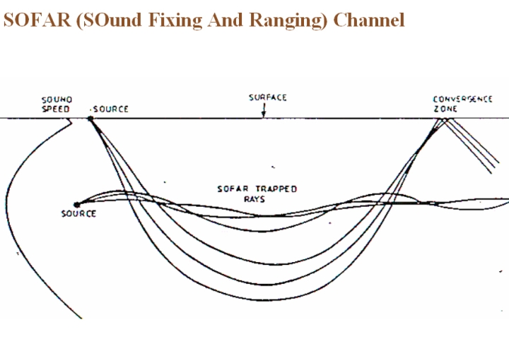
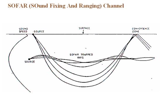
SOFAR (SOund Fixing And Ranging) Channel.
Sound propagates efficiently through water so that it can be heard and detected at great distances. There is one layer in the water where sound travel is slower but particularly efficient: the Sound Fixing and Ranging Channel, SOFAR, which is typically at a depth of about 1000 m. Hydroacoustic monitoring makes use of the unique phenomenon of sound waves being trapped in that layer.
Hydroacoustic technology first evolved at the beginning of the 20th century with the aim of increasing the safety of sea travel. Sound waves were emitted and their reflections measured off objects such as icebergs and shoals in the water. Called sonar (sound navigation and ranging), this technology was soon used for submarine navigation and detection.
Apart from military applications, this technology is of great use in a range of civil and scientific fields. Hydroacoustic technology helps in the research of whale populations and their migration patterns, in climate change studies and in tsunami warning systems. The technology also continues to be used where it first started, namely in increasing shipping safety.
Hydroacoustic technology is used to measure changes in the water pressure caused by sound waves. Data obtained from hydroacoustic monitoring provide information on the location of a nuclear explosion underwater, near the ocean surface or near a coastline.
Due to the efficient transmission of sound through water, even comparatively small signals are readily detectable at long distances. Thus, eleven stations are sufficient to monitor the Earth’s big oceans, with emphasis on the Southern Hemisphere which is largely dominated by water.
Hydroacoustic monitoring can be used to differentiate signals generated by nuclear explosions from signals caused by human activity or natural events. Those activities or events may include seismic profiling for oil exploration or military exercises, or natural occurrences like volcanic eruptions or underwater earthquakes.
How the hydroacoustic monitoring network works
There are two types of hydroacoustic stations, using different sensing techniques: hydrophone and T-phase.
Hydrophone sensors are underwater microphones that convert changes in water pressure caused by sound waves into electric signals that can then be measured.
The measuring equipment consists of two sets of three hydrophones on opposite sides of an island. A single set of hydrophones would not suffice as the island would create a shadow in which sound waves from the opposite direction would be blocked by the island. A second set of hydrophones deployed in that area eliminates the acoustic shadow.
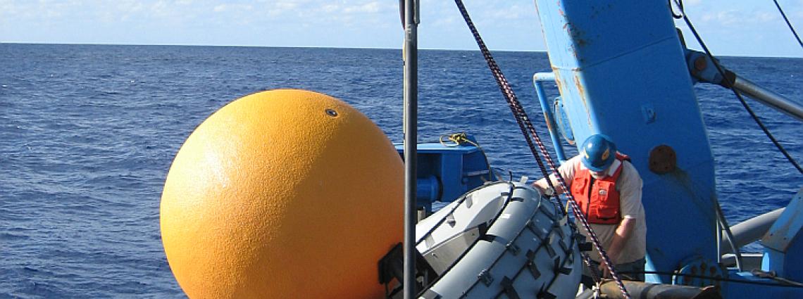
The hydrophones are located in the SOFAR channel at a depth of 600 to 1200 m, depending on location. To hold the sensors at the required depth, they are suspended from sub-surface floats and attached to ocean-bottom anchors.
The six hydrophone stations are based on islands in the three major oceans, Atlantic, Pacific and Indian.
Hydrophone stations are among the most challenging and most costly monitoring stations to build, involving the hiring of ships, extensive underwater work and the use of specially designed materials and equipment. Installations must function for 20 to 25 years in extremely inhospitable environments, exposed to near-freezing temperatures, huge pressures and saline corrosiveness.
The deployment of the underwater parts of a hydrophone station – placing the hydrophones and laying the cables – is a highly sophisticated and complex affair. The length of specially protected cables laid between the hydrophones and shore station equipment can exceed 100 kilometres, and depths of up to 5000 meters are encountered along the cable routes.
The five T-phase stations are located on oceanic islands with steep slopes. They use seismic sensors to detect waterborne acoustic energy, which is converted to seismic waves (T-phases) when hitting land. The stations are mostly three-component stations with one or more seismometers.
T-phase stations are less effective than hydroacoustic stations, but also considerably simpler and less costly to build.
Both types of station include data acquisition systems and communication equipment.