HA6, Socorro Island, Mexico

The island is of volcanic origin.

Thumbnail profile: Socorro Island

The station is located on Isla Socorro—its Spanish name—which is a 132 km² volcanic island in the Revillagigedo Islands, off Mexico’s western coast. A shield volcano that last erupted in 1993, the island rises abruptly out of the sea to an altitude of 1,050 m (3,445 ft.). Its terrain is full of furrows, small craters and ravines, and covered in lava domes, lava flows and cinder cones.

The Mexican Navy supported site construction by making boats available for transport.

Socorro Island was discovered by Spanish explorer Hernando de Grijalva on Christmas Day 1533. Rediscovered in 1608, it was named Isla Socorro ("Island of Aid") by explorer Martín Yañez de Armida. Much later, in the early 20th century, Barton Warren Evermann, Director of the California Academy of Sciences in San Francisco, began promoting the scientific exploration of the island, which is located 440 km southwest of Baja California’s southernmost point and 700 km from the Mexican mainland. Nowadays, the waters around Socorro Island are a popular destination for divers, especially for its large manta rays.

The waters around Socorro Island are renowned for their large manta rays. Photo: David McMurdie.

In the 1960s Socorro Island —along with Nord in Greenland, Easter Island, Heard Island in the Indian Ocean and Mawson Station on Antarctica — was a station in the Earth-girdling satellite triangulation programme set up by the United States Coast and Geodetic Survey. This early space-based geodetic system was a forerunner of today's Global Positioning System (GPS). Today there is a naval station on Socorro Island, which was established in 1957 and has a population of 250 staff and families. They live in a village on the west side of Bahia Vargas Lozano, a small cove with a rocky beach, about 800 metres east of Cabo Regla, the southernmost point of the island. The Mexican Navy supported the site construction and installations at HA06 by making boats available to transport personnel and equipment.

Aerial view of HA06's shore facility.

Station Profile

HA6 covers large parts of the North Pacific Ocean. The hydroacoustic T-phase facilities on Socorro Island are part of a new IMS station for which the site survey was carried out in 1999. As a result of the collaboration between the Preparatory Commission for the Comprehensive Nuclear-Test-Ban Treaty Organization (CTBTO) and the Geophysical Institute of the University of Mexico (Universidad Nacional Autónoma de Mexico, UNAM), three element sites are part of the T-phase facility of Socorro Island.

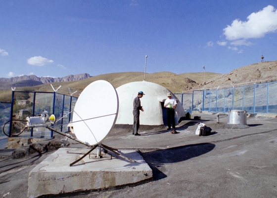
One of HA06's seismometer that can detect hydroacoustic waves that are converted to seismic waves when they hit the shore.

It uses seismometers to detect hydroacoustic waves that are converted to seismic waves when they hit the shore of an island. Each element site consists of three principal sub-structures: a data acquisition system, power supply system and satellite communications system. The remoteness of Socorro Island from major human settlements or traffic allows precise measurement results.

IMS Station Locations

There are three sites, each with a three-component seismic sensor. The northern seismometer is on the north tip of the island and accessible only by sea, departing from the Naval Base. The southern one is close to the shore and easily accessible while the eastern one is 300 m above sea level, about half a kilometre from the airstrip and reachable by car from the Naval Base. Learn more about how the hydroacoustic technology works.

Construction of HA06 began in April 2004.

Build-up, Certification, Testing and Evaluation

The station design plan was completed in 2003. Installation of the Central Recording Facility (CRF) in Mexico City took place in April 2003. Station construction began in April 2004 and the installation took place in June 2004. Certification tests were performed during the installation visit. Some tests had to be repeated in May 2005, following replacement of the sensors at one of the element sites due to chemical corrosion inside the vault. In December 2005 the satellite communications systems were repaired following the onslaught of Hurricane Hillary in August of that year.

The northern seismometer is on the north tip of the island and accessible only by sea.

A three-day buffer test at the CRF was performed remotely from Vienna for each of the stations. Data availability and timely data availability tests were completed between 8-19 December 2005 for all three station sites and the results were in excess of the 97% and 98% required thresholds. Thus, HA6 was certified on 22 December 2005. In addition to HA06, Mexico hosts three auxiliary seismic and one radionuclide station.