CTBTO contributes to tsunami warning following the earthquake in Chile

“The swing didn't stop, and that's when it got really, really scary,” recalled Adrien Lopez, an American working for the Chilean government, about the tragedy of the 27 February 2010. At around 3:30 am local time, an earthquake occurred off the coast of Chile. According to the U.S. Geological Survey, the 8.8 magnitude earthquake lasted for over three minutes and was felt by more than three million people, also damaging one and a half million houses. Besides causing massive destruction on land, very large earthquakes can generate a series of ocean waves, known as tsunamis, which can devastate nearby and distant coastal areas. CTBT data forwarded to tsunami warning centres  “Within less than a minute of their arrival in Vienna, data from about 20 seismic and hydroacoustic stations of the Preparatory Commission for the Comprehensive Nuclear-Test-Ban Treaty Organization (CTBTO) were forwarded to the tsunami warning centres in the Pacific region,” said Mark Prior, a seismic and acoustics specialist at the CTBTO. Swift alerts were issued to Chile,  other Latin American countries,  and the wider Pacific region. “We understand from our counterparts that our monitoring data have proven to be fast and reliable,” said Annika Thunborg, the CTBTO’s spokesperson. “The speed increases the ability of the warning centres to issue effective warnings,” she added. The Pacific Tsunami Warning Center issued its first warning 12 minutes after the earthquake.

Shake map of the United States Geological Survey.

Station stopped transmitting information Just a few hours after the earthquake, Mark Prior walked into his office to analyze the rich dataset detailing the event that was provided by the wider monitoring network. “We quickly noticed that 50 minutes after the earthquake, the nearest hydroacoustic station, located on the Juan Fernandez Island, had stopped transmitting information,” he said. “When we found the diagram with the tsunami travel time predictions, we realized this was a big issue,” Mark recalls. “One obviously thinks the worse first, but we did not know how bad it was.”

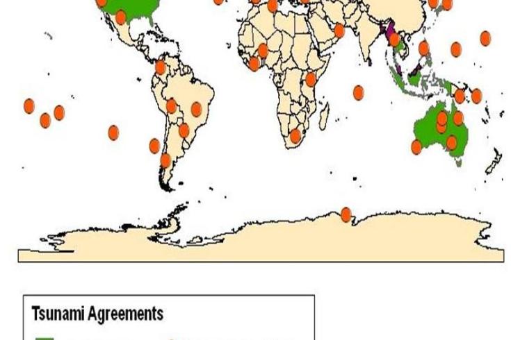
Stations transmitting data to tsunami warning centres around the globe.

Ground station on Juan Fernández Islands
Six hundred kilometere away from the earthquake’s epicenter, the ground station collecting the information from the sensors on and around the island is located directly on the shore. “After my colleagues received a picture with the devastated coast, and learned that many people had been killed, they were frantically trying to get hold of our local station operator,” said Mark. “It was Monday when we finally knew he was ok.” The ground station was nevertheless destroyed and it remains uncertain what damage the multiple sensors suffered.

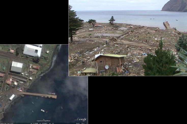
Close-up of buildings near the pier (left), and a picture taken after the disaster in the vicinity of the station location.

337-facility network to monitor the planet The Comprehensive Nuclear-Test-Ban Treaty (CTBT) bans all nuclear explosions.  The CTBTO is building a 337-facility network to monitor the planet for compliance with the Treaty.  When complete, seismic, hydroacoustic and infrasound stations will monitor underground, the oceans and the atmosphere. Radionuclide stations will sniff the air for any sign of a nuclear explosion.
The data produced by this network have a number of other possible uses. These include tsunami warning, but also research on the Earth’s core, monitoring of earthquakes and volcanoes, climate change research, atmospheric monitoring and biological research.

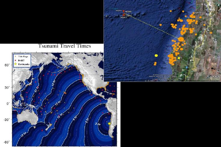
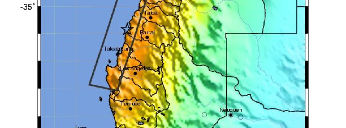
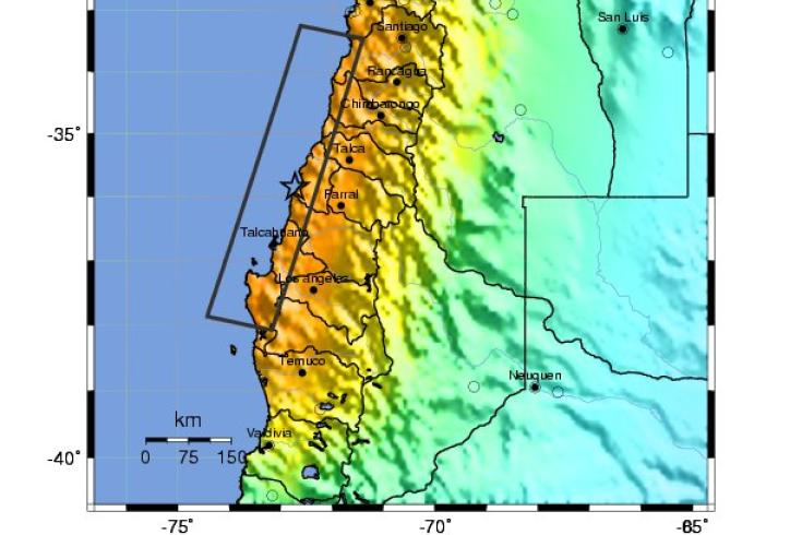
The closest International Monitoring System hydroacoustic station is located approximately 600 km from the event. The U.S. National Oceanic and Atmospheric Administration estimated that it would take the tsunami one hour to reach that distance.

40 stations contribute to tsunami warning centres The CTBTO is currently contributing data from close to 40 stations, representing three of the four CTBT verification technologies (seismic, hydroacoustic and infrasound), to regional tsunami warning centres in Japan and the United States (Alaska and Hawaii), and to national tsunami warning centres in Australia, Indonesia, Malaysia, the Philippines and Thailand.

“It's a key point to remember that we cannot under-warn. We cannot have a situation that we thought was no problem and then it's devastating. That just cannot happen,” Dai Lin Wang, an oceanographer at the Pacific Tsunami Warning Center in Hawaii, told the Associated Press.  “We learned that we are ready to deal with these situations,” Honolulu Emergency Management Department spokesman, John Cummings, told a press conference. “We at the CTBTO are happy that we can contribute to disaster mitigation,” said Tibor Tóth, the Executive Secretary of the CTBTO. “The tragedy in Chile is another reminder of the relevance of our investment.”

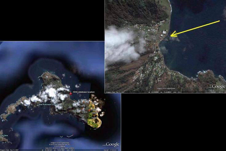
The ground station serving the various sensors is located on the shore in the region indicated on the map of Robinson Crusoe, one of the volcanic Juan Fernández Islands. The hydroacoustic sensors are in the water 25 km north of the station, and the infrasound sensors are located southeast, 300 to 400 metres above sea level.